Features
From instant identification to detailed formation analysis — tools designed for real geological work, not guesswork.
Point your camera at any rock, mineral, or outcrop. Get detailed scientific identification including composition, texture, grain size, and classification — with reasoning for why it's classified that way.
Analyse geological formations in the field — faults, folds, bedding planes, unconformities, and more. Understand the structural geology of what you're looking at.
Generate detailed pencil sketches of specimens with labelled geological features — perfect for field notebooks, study notes, or classroom handouts.

Discover a new rock or mineral every day with detailed geological context — build your knowledge one specimen at a time, from common quartz to rare pegmatites.
See today's rock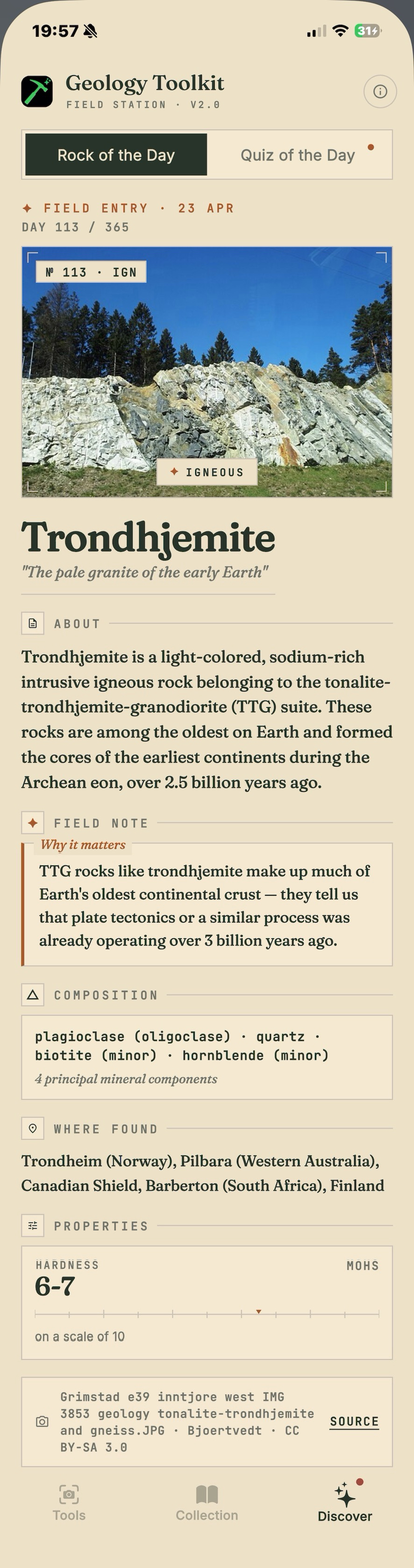
Save every identification to your personal collection. View your finds on a map, track where you've explored, and build a geological record of your fieldwork.
See It In Action
Point your camera at a rock and get the kind of detailed analysis you'd expect from a geology textbook — not a vague one-word label.
Ready to identify
Tap "Identify this rock" to see the analysis
How It Works
Four steps to turn any rock encounter into a learning moment.
Snap a photo of any rock, mineral, outcrop, or formation you encounter in the field or classroom.
AI analyses your photo and delivers a detailed scientific identification with composition, texture, and classification.
Understand why a rock is classified the way it is — formation process, geological context, and related specimens.
Generate annotated pencil sketches with labelled features — ready for your field notebook or study materials.
"Perfect companion for fieldwork — the formation analysis is genuinely useful."
— Geology Student
"Finally an app that explains why a rock is classified the way it is, not just a name."
— Earth Science Enthusiast
"The pencil sketch feature is brilliant for my study notes."
— University Student
Built for Real Geology
This isn't a novelty crystal identifier. Geology Toolkit delivers the kind of detailed, scientifically accurate analysis that geology students, educators, and field professionals actually need.
Every identification uses correct geological vocabulary — igneous, sedimentary, metamorphic classifications, Mohs hardness, crystal systems, and mineralogical composition.
We don't just tell you what a rock is — we explain why. Understand the diagnostic features, distinguishing characteristics, and how to tell similar specimens apart.
Learn the geological story behind each specimen — from magma cooling rates that determine crystal size to the metamorphic conditions that form foliation patterns.
Identification results are structured like a proper geological description — the kind you'd write in a field notebook or submit for coursework.
"Not just what it is — but why it is."
Every identification includes the reasoning chain: the diagnostic features observed, similar specimens ruled out, and the geological processes that formed it. Real understanding, not just a label.
FAQ
Geology Toolkit is available on iPhone, iPad, and Android devices. Download it from the App Store or Google Play.
You need an internet connection for AI-powered identification and formation analysis, as these features use advanced models that run in the cloud. Your saved collection and previously identified specimens are available offline.
Geology Toolkit is free to download with a limited number of identifications per day. For unlimited scans, sketch generation, and full access to all features, there's an optional subscription. We want everyone to be able to explore geology — the free tier is genuinely useful, not just a teaser.
Our AI is trained on extensive geological datasets and delivers results with scientific terminology and proper classification reasoning. Like any identification tool, accuracy improves with clear, well-lit photos. We always provide confidence levels and explain the diagnostic features used, so you can verify the reasoning yourself.
We take a privacy-first approach. Photos are processed for identification and are not stored on our servers after analysis. Your collection data stays on your device. We don't sell your data or use it for advertising. See our privacy policy for full details.
Absolutely. The identification format follows standard geological description conventions — rock type, texture, composition, formation process, and classification reasoning. Many geology students use it as a study companion and field reference. The pencil sketch feature is particularly useful for lab reports and field notebooks.